Documented Airspace Incidents

The Threat Is Real

Drones interfering with medevac helicopters, forcing airport ground stops, crashing in residential neighborhoods, and overflying critical infrastructure are not hypothetical scenarios. These incidents are documented, recurring, and consequential for governments, utilities, and facility operators.

"
Drone operators should expect swift action if they violate restricted airspace.
FAA Administrator Bryan Bedford — FIFA World Cup 2026 No Drone Zone Announcement

Documented Incidents & Source Material

Real Events. Real Consequences.

Every entry below is drawn from news reporting, FAA records, federal law enforcement, or official government sources. These are not hypothetical scenarios — they are documented, recurring, and consequential for the organizations that operate in or around affected airspace.

Commercial aircraft on approach to airport runway
Airports & AviationJune 2026

"We Almost Hit a Drone."

In June 2026, the crew of a United Airlines Boeing 737 on approach to Newark Liberty International Airport reported nearly striking a drone. The pilot told air traffic control directly: "We almost hit a drone." The crew estimated the drone passed approximately 100 feet below the aircraft. A second pilot approaching Newark also reported seeing a drone in the area. The FAA opened an investigation.

Incidents like this illustrate that UAS activity surrounding an airport is not limited to airport property. Understanding where detectable drone activity occurs — when, at what altitudes, and whether recurring patterns exist — gives aviation stakeholders a clearer picture of their low-altitude environment before the next close call.

Emergency aircraft firefighting operations aerial
Public SafetyJanuary 2025

Drone Collides With Firefighting Aircraft During the Palisades Fire

During the Palisades Fire in California in January 2025, an unauthorized drone operating inside an active FAA Temporary Flight Restriction collided with a firefighting aircraft — a Super Scooper. According to the FBI, the collision punched an approximately 3-by-6-inch hole in the aircraft's wing. The aircraft landed safely, but the incident could have been catastrophic.

The case illustrates a fundamental challenge in increasingly complex low-altitude airspace: your aircraft may not be the only aircraft operating there. Police, fire, lifeguard, and emergency-management agencies are rapidly adopting UAS — but operating your own drone does not automatically provide awareness of every other aircraft in the same airspace.

Delivery drone crash debris on ground near building
Delivery OperationsFebruary 2026

Amazon Prime Air Delivery Drone Crashes Into Texas Apartment Building

In February 2026, an Amazon Prime Air delivery drone crashed into an apartment building in Richardson, Texas. Video from the incident showed the aircraft near the building before debris fell and the drone struck the ground. Firefighters responded. No injuries were reported and the building sustained minor damage — but the incident underscores what happens when autonomous delivery operations enter dense residential airspace.

Amazon has announced plans to expand Prime Air drone delivery to approximately 500 U.S. cities and towns by end of 2026. FAA environmental documentation for Amazon's Texas operations considered up to 1,000 MK30 delivery-drone flights per operating day from a single delivery center. Communities of the future may not encounter an occasional recreational drone — they may see hundreds of automated delivery operations daily, alongside recreational pilots, commercial operators, and public-safety UAS.

Secure federal facility perimeter fence
Secure FacilitiesJune 2026

12 Charged in Drone Contraband Ring Targeting 10 Federal Prisons

In June 2026, federal prosecutors announced charges against 12 individuals accused of participating in a drone-based contraband-smuggling operation spanning 10 federal prisons. Authorities alleged that heavy-payload drones conducted at least 38 contraband drops between September 2023 and May 2026 — bypassing fences, gates, checkpoints, cameras, and patrols entirely by approaching from above.

Traditional security is designed around a physical perimeter. UAS introduce another direction of approach: above. Organizations responsible for secure facilities — correctional, government, critical infrastructure — increasingly need to consider the airspace above and surrounding their traditional perimeter as part of their security posture.

Aerial view of stadium and surrounding airspace
Sports & EventsApril 2026

FAA Cracks Down on Illegal Drone Operations at Coors Field — and Establishes No Drone Zones for the FIFA World Cup

In April 2026, the FAA announced that more than half a dozen drone operators had been identified for violations involving drone operations around Coors Field during the Colorado Rockies' first homestand of the season. Federal restrictions prohibit unauthorized UAS operations within three nautical miles of qualifying major sporting events — MLB, NFL, NCAA Division I football, and major motorsports — from the surface to 3,000 feet AGL during specified periods.

For the 2026 FIFA World Cup, the FAA established No Drone Zones around stadiums, FIFA Fan Festival locations, and other designated sites. The pattern is consistent: large-scale events require security planners to consider not only the traditional ground perimeter, but the low-altitude airspace surrounding the event. Unauthorized UAS operations continue to occur despite established restrictions — and without airspace awareness, operators have no way to know what is happening above the crowd.

411

Illegal drone incursions near U.S. airports in Q1 2025 alone — up 25% vs. the same period in 2024

Source: FAA

3,000+

Drone events reported near U.S. airports since 2021, with 11 aircraft forced to take evasive action in 2025

Source: FAA Records

2,845

Unauthorized drone flights detected over NFL stadiums in 2023 — up from 2,537 in 2022

Source: NFL / NORAD

By the Numbers

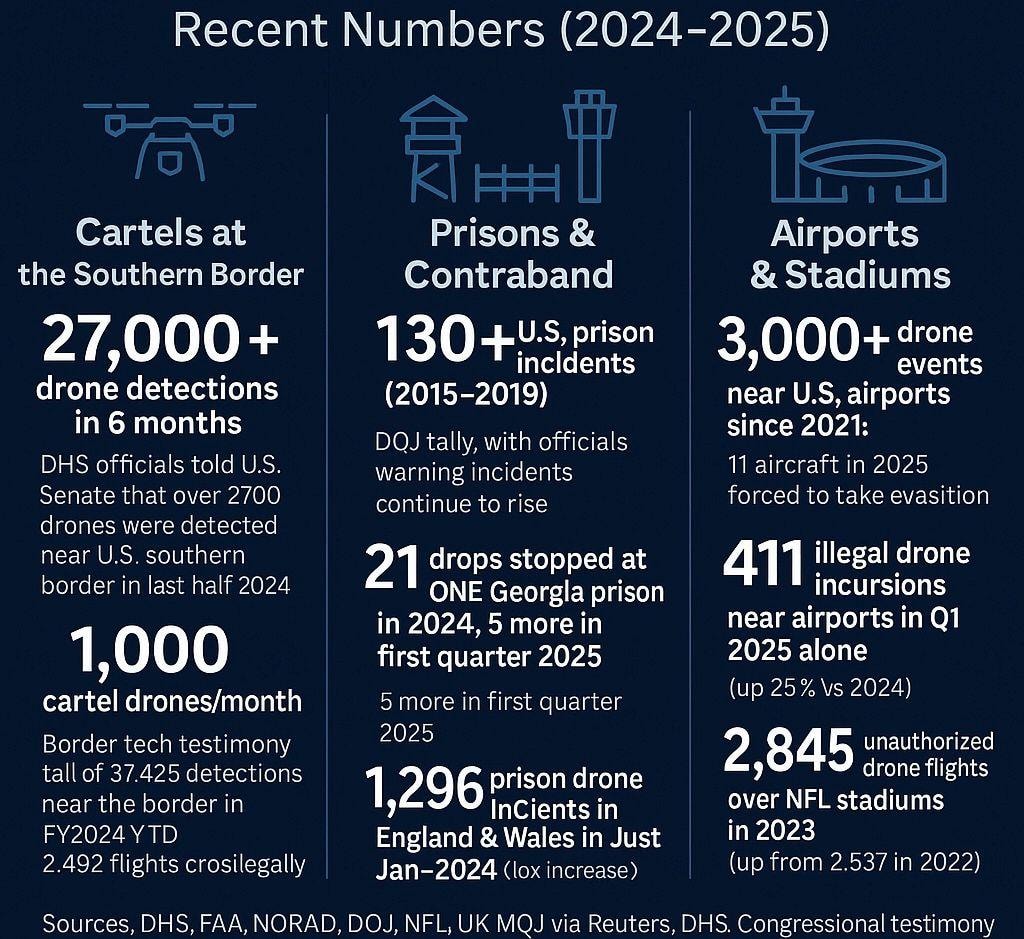
Recent Numbers (2024–2025)

Drone incidents are not isolated events. Across borders, correctional facilities, airports, and stadiums, the data shows a consistent and accelerating pattern.

Drone incident statistics and security threat data 2024–2025

Cartels at the Southern Border

27,000+

drone detections in 6 months

DHS officials told the U.S. Senate that over 27,000 drones were detected near the U.S. southern border in the last half of 2024.

1,000

cartel drones per month

Border technology testimony tallied 37,425 detections near the border in FY2024 YTD, with 2,492 flights crossing illegally.

Prisons & Contraband

130+

U.S. prison incidents (2015–2019)

DOJ tally, with officials warning incidents continue to rise.

21

drops stopped at one Georgia prison in 2024

5 more in the first quarter of 2025 at the same facility alone.

1,296

prison drone incidents in England & Wales

Recorded in January 2024 alone — a significant year-over-year increase.

Airports & Stadiums

3,000+

drone events near U.S. airports since 2021

11 aircraft in 2025 were forced to take evasive action due to drone proximity.

411

illegal drone incursions near airports in Q1 2025 alone

Up 25% vs. the same period in 2024.

2,845

unauthorized drone flights over NFL stadiums in 2023

Up from 2,537 in 2022 — a consistent year-over-year increase.

Sources: DHS, FAA, NORAD, DOJ, NFL, UK Ministry of Justice via Reuters, DHS Congressional testimony.

The Changing Low-Altitude Environment

Authorized Flights Create New Risks Too

The conversation about drone risk is not limited to unauthorized operators. FAA-approved commercial delivery drones, Drone as First Responder programs, and VTOL operations are expanding rapidly — and they bring a different set of challenges for local government, public safety agencies, and critical infrastructure operators.

Drone as First Responder

Your Drone Isn't the Only Drone in the Airspace

DFR programs give law enforcement, fire, and emergency services significant operational capabilities. But knowing where your own aircraft is does not tell you what else is operating nearby. The same airspace may simultaneously contain recreational drones, commercial UAS, news and media aircraft, infrastructure inspections, delivery drones, other public-safety aircraft, and future autonomous operations.

The FAA recognizes this challenge directly. According to the FAA, as drone operations become increasingly frequent and begin operating within overlapping areas, the risk of drone-to-drone conflict increases. The FAA's UAS Traffic Management framework addresses capabilities including flight planning, surveillance, strategic coordination, and conflict management for increasingly complex low-altitude operations.

Delivery Expansion

500 Cities. Hundreds of Flights Per Day. Do You Have a Baseline?

In August 2026, Reuters reported that Amazon planned to expand Prime Air drone delivery to approximately 500 U.S. cities and towns by end of 2026. FAA environmental documentation for Amazon's Texas operations considered up to 1,000 MK30 delivery-drone flights per operating day from a single delivery center.

For municipalities and public-safety organizations, this raises a critical question: how will you understand what normally operates in your community — and recognize activity that falls outside that baseline? Without a documented airspace picture, every incident is a surprise.

The Future Low-Altitude Environment

The Airspace Is Becoming More Complex

The low-altitude environment of the near future may simultaneously include all of the following — operating in overlapping areas, at overlapping times, without a unified operating picture for the organizations below:

Recreational drones
Commercial UAS
Drone as First Responder
Police & fire UAS
Lifeguard & SAR drones
Medical delivery
Package delivery
Infrastructure inspections
News & media operations
Special-event operations
BVLOS operations
Advanced Air Mobility
VTOL aircraft
Autonomous aircraft
Military & federal UAS
Counter-UAS operations

Organizations cannot effectively prepare for this environment without first understanding what is occurring around them. Establishing a baseline of detectable UAS activity helps organizations understand normal operating patterns, identify recurring areas of activity, and make more informed decisions regarding preparedness, policy, procedures, and future detection requirements.

Understanding Remote ID

Remote ID Provides an Important Layer of Airspace Awareness

The FAA describes Remote ID as the ability of a drone in flight to provide identification and location information that can be received by other parties. Remote ID can provide valuable information regarding compliant broadcasting aircraft and can help organizations understand where detectable drones are operating, their flight paths, altitudes, dates and times of activity, recurring operating patterns, and changes in activity over time.

Important Limitation

Remote ID awareness is not comprehensive counter-UAS detection. Remote ID receivers detect compliant Remote ID broadcasts within the capabilities and coverage of the receiving system. Aircraft that are not broadcasting Remote ID, aircraft operating under authorized exceptions, noncompliant aircraft, or aircraft using technologies outside the capabilities of the receiver may not be detected.

AirAware Technologies does not represent Remote ID monitoring as identification of every UAS operating within an area. Detection capabilities vary based on technology, environment, aircraft configuration, and other factors.

Local & State Government

Establish a documented airspace baseline for your jurisdiction before delivery corridors are finalized. Informed data supports planning, emergency response, and engagement with federal authorities.

DISCUSS YOUR JURISDICTION

Critical Infrastructure

Persistent airspace monitoring around transmission corridors, substations, water systems, and generation facilities turns unknown drone activity into a documented, actionable record.

REQUEST AN ASSESSMENT

Emergency Management

Drone incidents — crashes, unauthorized overflights, airspace conflicts — require coordinated response. Airspace awareness data gives emergency managers the context to act decisively.

CONTACT OUR TEAM

Know What Is Operating Near You

Does Your Facility Have a Clear Picture of Its Airspace?

AirAware Technologies conducts site-specific airspace assessments that document what is actually operating in and around your facility — UAS, manned aircraft, authorized delivery operations, and emerging VTOL traffic. The result is an informed baseline you can act on.